CAPE COD – Interests in the northeast including the Cape and Islands are being advised to monitor Tropical Storm Henri which could pass over or near the Cape on Sunday:
Link to National Hurricane Center
Link to National Weather Service in Boston
Latest advisory: BULLETIN
Tropical Storm Henri Advisory Number 16
NWS National Hurricane Center Miami FL AL082021
500 PM EDT Thu Aug 19 2021
…HENRI EXPECTED TO STRENGTHEN ON FRIDAY AND OVER THE WEEKEND…
…INTERESTS IN THE NORTHEASTERN U.S. SHOULD MONITOR ITS PROGRESS…
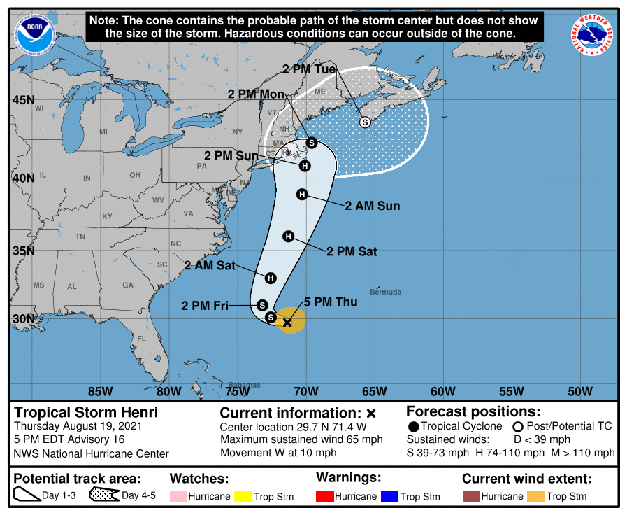
SUMMARY OF 500 PM EDT…2100 UTC…INFORMATION
———————————————-
LOCATION…29.7N 71.4W
ABOUT 450 MI…720 KM SSE OF CAPE HATTERAS NORTH CAROLINA
ABOUT 800 MI…1285 KM S OF NANTUCKET MASSACHUSETTS
MAXIMUM SUSTAINED WINDS…65 MPH…100 KM/H
PRESENT MOVEMENT…W OR 270 DEGREES AT 10 MPH…17 KM/H
MINIMUM CENTRAL PRESSURE…997 MB…29.44 INCHES
WATCHES AND WARNINGS
——————–
There are no coastal watches or warnings in effect.
Interests in the northeastern U.S. and Atlantic Canada should
monitor the progress of Henri. Watches will likely be required for
a portion of this area early Friday.
DISCUSSION AND OUTLOOK
———————-
At 500 PM EDT (2100 UTC), the center of Tropical Storm Henri was
located near latitude 29.7 North, longitude 71.4 West. Henri is
moving toward the west near 10 mph (17 km/h) and this motion is
expected to through tonight. A turn toward the northwest
is forecast on Friday, followed by an acceleration toward the north
and north-northeast Saturday and Sunday. On the forecast track, the
center of Henri will remain well offshore of the east coast of the
United States over the next couple of days, but it is forecast to be
near southern New England on Sunday and Monday.
Maximum sustained winds are near 65 mph (100 km/h) with higher
gusts. Little change in strength is expected during the next 12
to 24 hours, but Henri is forecast to intensify into a hurricane by
Friday night with additional strengthening expected this weekend.
Tropical-storm-force winds extend outward up to 90 miles (150 km)
from the center.
The estimated minimum central pressure is 997 mb (29.44 inches).
HAZARDS AFFECTING LAND
———————-
RAINFALL: Henri may produce rainfall amounts of 2 to 5 inches over
southeastern New England Sunday into Monday, with isolated maximum
totals near 8 inches. Heavy rainfall from Henri may result in areas
of flash, urban, and small stream flooding.
SURF: Swells generated by Henri should continue to affect Bermuda
during the next day or so. Swells are expected to increase across
much of the east coast of the U.S. and Atlantic Canada later this
week and this weekend. These swells could cause life-threatening
surf and rip current conditions. Please consult products from your
local weather office.
Boston statement: Hazardous Weather Outlook
National Weather Service Boston/Norton MA
447 AM EDT Thu Aug 19 2021
This Hazardous Weather Outlook is for northern Connecticut, all of
Massachusetts east of Berkshire County, and Rhode Island.
.DAY ONE…Today and tonight.
Hazardous weather is not expected at this time.
.DAYS TWO THROUGH SEVEN…Friday through Wednesday.
Tropical Storm Henri is forecast to track near Cape Cod and the
Islands or just offshore Sunday into Monday. There is the potential
for damaging winds, flooding rainfall, and storm surge flooding.

Tim Caldwell/CWN file
______
Today is the 30th anniversary of Hurricane Bob, the last major hurricane to hit the Cape. One of the most iconic photos of that story was this scene on Commercial Street in Provincetown in the far west end by the West End Lot. A huge tree uprooted onto a house.