 BULLETIN - EAS ACTIVATION REQUESTED
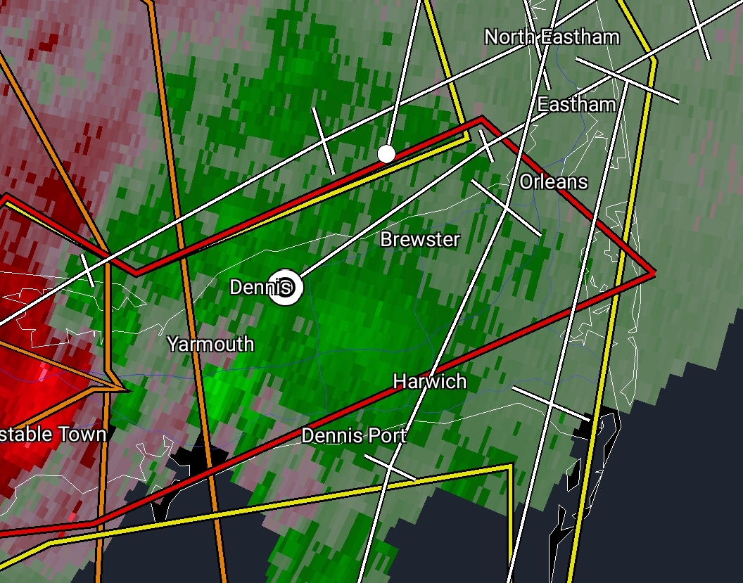
Tornado Warning
National Weather Service Boston/Norton MA
1153 AM EDT Tue Aug 8 2023
The National Weather Service in Boston/Norton has issued a
* Tornado Warning for...
Southeastern Barnstable County in southeastern Massachusetts...
* Until 1230 PM EDT.
* At 1153 AM EDT, a severe thunderstorm capable of producing a
tornado was located over Barnstable, moving northeast at 40 mph.
HAZARD...Tornado.
SOURCE...Radar indicated rotation.
IMPACT...Flying debris will be dangerous to those caught without
shelter. Mobile homes will be damaged or destroyed.
Damage to roofs, windows, and vehicles will occur. Tree
damage is likely.
* This dangerous storm will be near...
Barnstable, Yarmouth, Sandwich, and Dennis around 1200 PM EDT.
Brewster and Harwich around 1205 PM EDT.
Orleans around 1215 PM EDT.
Other locations impacted by this tornadic thunderstorm include
Hyannis.
PRECAUTIONARY/PREPAREDNESS ACTIONS...
TAKE COVER NOW! Move to a basement or an interior room on the lowest
floor of a sturdy building. Avoid windows. If you are outdoors, in a
mobile home, or in a vehicle, move to the closest substantial shelter
and protect yourself from flying debris.
Torrential rainfall is occurring with this storm, and may lead to
flash flooding. Do not drive your vehicle through flooded roadways.
BULLETIN - EAS ACTIVATION REQUESTED
Tornado Warning
National Weather Service Boston/Norton MA
1153 AM EDT Tue Aug 8 2023

The National Weather Service in Boston/Norton has issued a

* Tornado Warning for...
  Southeastern Barnstable County in southeastern Massachusetts...

* Until 1230 PM EDT.

* At 1153 AM EDT, a severe thunderstorm capable of producing a
  tornado was located over Barnstable, moving northeast at 40 mph.

  HAZARD...Tornado.

  SOURCE...Radar indicated rotation.

  IMPACT...Flying debris will be dangerous to those caught without
           shelter. Mobile homes will be damaged or destroyed.
           Damage to roofs, windows, and vehicles will occur.  Tree
           damage is likely.

* This dangerous storm will be near...
  Barnstable, Yarmouth, Sandwich, and Dennis around 1200 PM EDT.
  Brewster and Harwich around 1205 PM EDT.
  Orleans around 1215 PM EDT.

Other locations impacted by this tornadic thunderstorm include
Hyannis.

PRECAUTIONARY/PREPAREDNESS ACTIONS...

TAKE COVER NOW! Move to a basement or an interior room on the lowest
floor of a sturdy building. Avoid windows. If you are outdoors, in a
mobile home, or in a vehicle, move to the closest substantial shelter
and protect yourself from flying debris.

Torrential rainfall is occurring with this storm, and may lead to
flash flooding. Do not drive your vehicle through flooded roadways.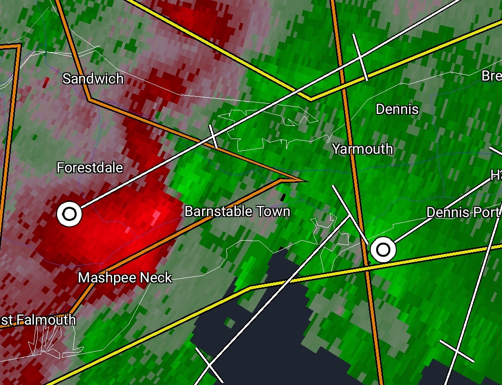
230808T1630Z/
BULLETIN – IMMEDIATE BROADCAST REQUESTED
Severe Thunderstorm Warning
National Weather Service Boston/Norton MA
1137 AM EDT Tue Aug 8 2023
The National Weather Service in Boston/Norton has issued a
* Severe Thunderstorm Warning for…
Northwestern Dukes County in southeastern Massachusetts…
Barnstable County in southeastern Massachusetts…
Southeastern Plymouth County in southeastern Massachusetts…
* Until 1230 PM EDT.
* At 1137 AM EDT, severe thunderstorms were located along a line
extending from near Carver to near Bourne to near Falmouth to near
Gosnold, moving northeast at 30 mph.
HAZARD…60 mph wind gusts.
SOURCE…Radar indicated.
IMPACT…Expect damage to roofs, siding, and trees.
* Locations impacted include…
Plymouth, Barnstable, Falmouth, Brewster, Marion, Provincetown,
Yarmouth, Middleborough, Wareham, Sandwich, Bourne, Dennis,
Mashpee, Kingston, Harwich, Carver, Chatham, Mattapoisett, Orleans,
and Rochester.
PRECAUTIONARY/PREPAREDNESS ACTIONS…
For your protection move to an interior room on the lowest floor of a
building.
Torrential rainfall is occurring with these storms, and may lead to
flash flooding. Do not drive your vehicle through flooded roadways.

BULLETIN – EAS ACTIVATION REQUESTED
Tornado Warning
National Weather Service Boston/Norton MA
1118 AM EDT Tue Aug 8 2023
The National Weather Service in Boston/Norton has issued a
* Tornado Warning for…
Western Barnstable County in southeastern Massachusetts…
Southeastern Plymouth County in southeastern Massachusetts…
East central Bristol County in southeastern Massachusetts…
* Until 1145 AM EDT.
* At 1118 AM EDT, a severe thunderstorm capable of producing a
tornado was located over Mattapoisett, or near Marion, moving
northeast at 20 mph.
HAZARD…Tornado.
SOURCE…Radar indicated rotation.
IMPACT…Flying debris will be dangerous to those caught without
shelter. Mobile homes will be damaged or destroyed.
Damage to roofs, windows, and vehicles will occur. Tree
damage is likely.
* This dangerous storm will be near…
Marion, Middleborough, Wareham, Acushnet, Mattapoisett, and
Rochester around 1125 AM EDT.
PRECAUTIONARY/PREPAREDNESS ACTIONS…
TAKE COVER NOW! Move to a basement or an interior room on the lowest
floor of a sturdy building. Avoid windows. If you are outdoors, in a
mobile home, or in a vehicle, move to the closest substantial shelter
and protect yourself from flying debris.
Torrential rainfall is occurring with this storm, and may lead to
flash flooding. Do not drive your vehicle through flooded roadways

Dopper radar (precipiation)
Doppler radar (velocity mode showing rotation over water south of New Bedford)
Severe Thunderstorm Warning
BULLETIN – IMMEDIATE BROADCAST REQUESTED
Severe Thunderstorm Warning
National Weather Service Boston/Norton MA
1048 AM EDT Tue Aug 8 2023
The National Weather Service in Boston/Norton has issued a
* Severe Thunderstorm Warning for…
Northwestern Dukes County in southeastern Massachusetts…
Southwestern Barnstable County in southeastern Massachusetts…
Southern Plymouth County in southeastern Massachusetts…
Southeastern Bristol County in southeastern Massachusetts…
Northeastern Newport County in Rhode Island…
Southeastern Bristol County in Rhode Island…
* Until 1145 AM EDT.
* At 1048 AM EDT, severe thunderstorms were located along a line extending from near Tiverton to 6 miles southeast of Little Compton to 12 miles west of Gosnold to 14 miles southeast of Newport, moving northeast at 30 mph.
HAZARD…60 mph wind gusts.
SOURCE…Radar indicated.
IMPACT…Expect damage to roofs, siding, and trees.
* Locations impacted include…
New Bedford, Fall River, Plymouth, Taunton, Dartmouth, Falmouth, Bristol, Marion, Middleborough, Wareham, Sandwich, Bourne, Somerset, Portsmouth, Fairhaven, Swansea, Tiverton, Westport, Duxbury, and Mashpee.
PRECAUTIONARY/PREPAREDNESS ACTIONS…
For your protection move to an interior room on the lowest floor of a building.
Torrential rainfall is occurring with these storms, and may lead to flash flooding. Do not drive your vehicle through flooded roadways.

Rip Current Statement
Coastal Hazard Message
National Weather Service Boston/Norton MA
142 PM EDT Mon Aug 7 2023
…HIGH RIP CURRENT RISK IN EFFECT FROM TUESDAY MORNING THROUGH TUESDAY AFTERNOON…
* WHAT…Dangerous rip currents expected.
* WHERE…Washington, Southern Bristol MA, Southern Plymouth MA, Barnstable MA, Dukes MA, Nantucket MA, and Newport RI Counties.
* WHEN…From Tuesday morning through Tuesday afternoon.
* IMPACTS…Rip currents can sweep even the best swimmers away from shore into deeper water.
PRECAUTIONARY/PREPAREDNESS ACTIONS…
Swim near a lifeguard. If caught in a rip current, relax and float. Don`t swim against the current. If able, swim in a direction following the shoreline. If unable to escape, face the shore and call or wave for help.