


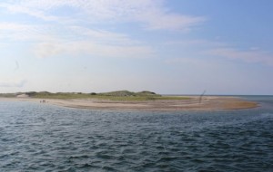
CCB MEDIA PHOTO
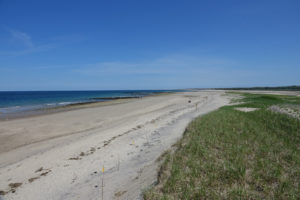
A large “knob” has grown from sand deposits at the tip of Sandy Neck, while further west down the coast, beaches in Sandwich have been starved of sand.
BARNSTABLE – Ever since the days the Pilgrims landed on these shores in 1620, the population has grown—first slowly, then quickly—and land use has spread throughout the peninsula, particularly along the coast.
At the same time, the sea around the peninsula has been shaping the land, cutting back in some areas and adding land in others. It is this process of steady erosion that has caused several Cape towns to take drastic action, for example, the town of Sandwich looking to spend millions on beach re-nourishment, and other towns, like Falmouth, to take a more measured approach, having a committee several years ago study erosion processes and draw up a 100-year plan for its coast.
The town of Sandwich along the Cape’s north shore is one example where the sharp carving of the coast has put homes and even the town center in jeopardy, leading officials to take what one Sandwich Town Manager George “Bud” Dunham called “drastic measures’ in attempts to buttress the beach closest to the Cape Cod Canal.
At a meeting this spring in front of the state’s Coast Erosion Commission, Dunham called the erosion impact to his town “staggering.”
Beach nourishment projects are meant to, as Sandwich Selectman Patrick Ellis put it at a summer meeting with the Army Corps of Engineers, “put back what nature has taken away,” but, officials note, the millions being spent are in danger of being swept back out to sea in future storms.
At the same time, there has been change in the opposite direction further down the coast, for example at the tip of Sandy Neck, a barrier beach protecting Barnstable Harbor. Sand deposited from numerous storms over 200 years and the natural ebb and flow of the tides has added acres of dunes, putting the lighthouse, considerably west of the tip.
The light was originally built in 1826 at the eastern most extremity of the barrier beach at the opening of the harbor and it was moved 200 feet closer to the tip in 1931, according to a history by the group, Lighthouse Friends.
Land use on the entire peninsula of Cape Cod has played a major role in erosion, according to research compiled by the Woods Hole Research Center in collaboration with the Cape Cod Commission in the report, “Losing Cape Cod, Saving Cape Cod: Land Use and Climate Change Over Time.”
As far back as the 1700s, agricultural use of the land and culling the Cape’s forest for firewood resulted in severe deforestation, an effect that can still be seen in the wide treeless landscapes in early photographs of the Cape taken in the late 1800s.
“Extensive land-clearing in the 1700s led to a wood shortage and to degrading and eroding of the fertile soils by the 1800s,” the report noted.
Although these were just the early years of the Cape’s development, already colonists had to bring wood in by ship to deal with the shortage and, in a harbinger of things to come, the Cape’s estuaries and harbors were being filled in by sand loosened from erosion caused by clearing of trees and brush.
Farming remained the primary Cape industry in the 1800s but historians note the lack of stewardship that resulted in damage to the land, sapping it of nutrients.
By the late 1800s, the forest began to grow back but the Cape had been discovered as a seaside escape.
The canal dredging in 1915 and subsequent construction of the Bourne and Sagamore bridges meant increased access to the peninsula. In this “automobile age,” development started relatively slowly but picked up precipitously in the 1950s and 1970s-80s, in a period in which the Cape saw explosive population growth.
Between 1940 and 2003, according to statistics compiled by the Woods Hole Research Center, the Cape’s population grew 515 percent.
“In many ways, population growth on Cape Cod has mirrored the expansion of the interstate highway system,” according to the report, “Losing Cape Cod, Saving Cape Cod.”
State officials in Massachusetts have been mapping the commonwealth’s land cover since 1951. Maps showing land use patterns from 1951 to the present show the shrinking open space and spread of housing developments creeping every farther from town centers.
In 1951, well over half the Cape was forested, but today, the split in the Cape’s land use is frequently given in thirds, according to Association to Preserve Cape Cod Execuitive Director Ed Dewitt, with one-third being preserved as open space, one-third as residential development and one-third “up for grabs,” meaning it could go to conservation or development.
But as the Cape continues to grow, particularly along the coast, homes have been built more frequently in flood plains.
When emergency planning officials look at the Cape’s shoreline, they can pinpoint areas that are vulnerable to flood in heavy storms.
Sandwich from Town Neck Beach to the town’s center is just one of the town centers in danger from storm flooding.
The area near Barnstable Harbor, including Barnstable Village; Chatham Center; the shoreline at the head of Waquoit Bay in Falmouth; the Cape’s coastline as it heads through Brewster, Orleans and Eastham; the coasts of Hyannis and Yarmouth, particularly near Lewis Bay; Wellfleet Harbor and Provincetown are all included in maps showing where roads and flooding coincide and direct damage to homes and infrastructure will be greatest, according to the Woods Hole Research Center’s report.
According to the US Geological Survey, it is impossible to know whether the Cape is eroding at a faster pace than ever in its existence, but the changes over the past 80 years have been extensively studied.
The erosion rates figure given most commonly for oceanfront land in the Outer Cape towns from Eastham through Truro is three feet per year. When both Highland (Cape Cod) Light in Truro and Nauset Light in Eastham were moved back from the edge of their respective bluffs in the 1990s, the concern was that the present rates of erosion would undermine the cliffs within 10 years.
But, according to USGS, “short-term average rates of erosion can be very misleading because the locus of erosion will change over time and one part of the lower Cape may be undergoing rapid erosion while other parts may be stable for decades. In addition, in other places, the beach may become wider as sand is added to the beach face, causing the shoreline to move seaward.”
Between 1938 and 1974, according to USGS, average rates of erosion along the Atlantic Ocean shoreline in Wellfleet and Truro where the dunes are as high as 50 feet tall “ranged from a high of about nine feet per year to a low of a few inches per year, and the average rates for Chatham’s barrier beach, North Beach, ranged from about 19 feet per year to three feet per year.
There is evidence that the sea level is rising much more quickly now than it has over the past 2,000 years. According to USGS, the sea level around Cape Cod rose only about six and a half feet over the past 2,000 years, for over the past 100 years, the level rose one foot.
“This much faster rate of sea-level rise would be expected to cause greater rates of erosion, and, if this increase in the rate of sea-level rise continues, it is logical to assume the rates of erosion will increase too,” according to USGS.
Nauset Inlet in Orleans and Eastham and changes in North Beach, the barrier beach off Chatham, have been documented for hundreds of years and the shoreline shift occurs with regularity, with each winter storm season bringing a new configuration of harbor openings.
The Cape’s sandy surface is the reason it is so vulnerable to the erosion processes of wind and surf.
The bad news is scientists estimate the Cape will continue to erode at a rapid rate. The good news is that it will likely not completely disappear for another thousand years.
USGS scientists have determined, “Cape and Islands will continue to erode because, with or without sea-level rise, the loose sand of the glacial Cape has no resistance to wave attack. Continued sea-level rise will accelerate the erosion and cause the demise of the Cape to occur sooner. However, it will take thousands of years before the Cape is reduced to shoals and low-lying islands and perhaps five or six thousand years be completely drowned by the sea.”
By LAURA M. RECKFORD, CapeCod.com NewsCenter


who wrote this awesome story?